Ordnance Survey
Great Britain's Islands Relief Map
Free delivery on all orders (more info)
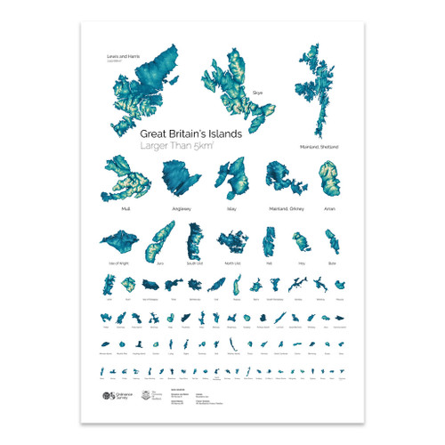
Great Britain's Largest Islands - Larger than 5km2 Relief Map. By Ordnance Survey in collaboration with the University of Sheffield.
Available to purchase as an A3 relief 2D flat map.
About Great Britain's Largest Islands Relief Map
Ordnance Survey's GeoDataViz team worked with Alasdair Rae at the University of Sheffield to explore the largest of Britain’s islands.
The team found that there are 82 English, Scottish and Welsh islands larger than 5km2. Scotland contains the majority of islands with 71. With some well known Scottish islands: the Outer Hebrides, Shetland and Orkney.
Read about Island82, following OS Champion Lisa Drewe on a mission to visit all 82 islands.
Reviews
Delivery times
Order before 3pm weekdays for:
- Free standard delivery in up to five working days
- 1st Class delivery in 1-2 working days
- Priority Express Next Day delivery on the next working day
OS Historical 1896-1904 Maps, Relief Maps and Custom Made Map orders will take one extra day for printing. Framed and canvas products are handmade and usually take 10-12 working days to dispatch. If you order on a bank holiday we'll start on your order on the next working day. Standard delivery for OS Historical 1896 - 1904 Maps and Relief Maps are sent RM 48, and Next Day Delivery will be sent out Royal Mail 24.
An estimated delivery date will be shown in checkout once you enter your address and pick a delivery option.
Sorry, we do not currently deliver outside of the UK.
See Full Delivery information here.


