
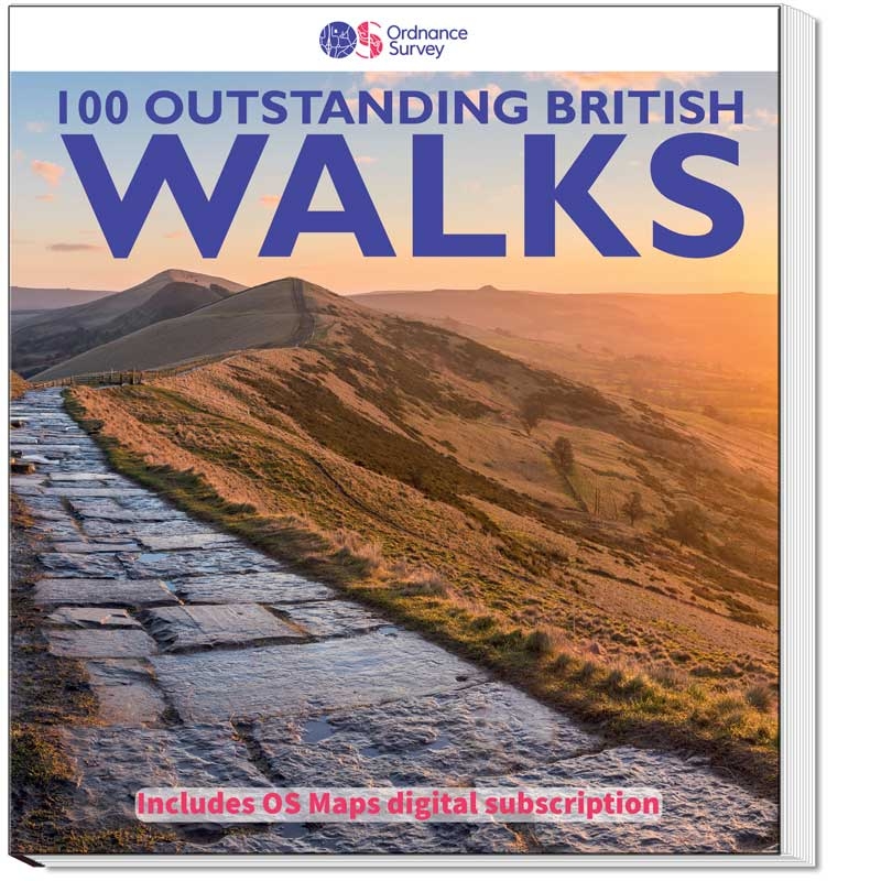
100 Outstanding British Walks
Find the routes and access detailed mapping for this epic book
Redeem OS Maps code
Get six months access to OS Maps Premium, allowing you to see all the walks on our most detailed mapping, print maps, view in 3D, follow the walks on a mobile device and much more.
- Scratch off the silver panel on the rear inside cover to reveal your unique code
- Go to the OS Maps 6 months access page and add it to cart
- In the checkout, enter your unique code in the 'Discount code' box
- Complete the checkout process to create your OS Maps account
Once you have created your account, you can follow any of the route links below. Once OS Maps is open, log in using the link in the top right (if you are not already logged in).
You can switch to our most detailed Leisure mapping, Aerial 3D view or other map types using the map layer switch in the bottom right. For more help getting started using OS Maps, see the OS Maps Guide.
Discover the walks
Drag with your mouse to scroll the map and use your mouse wheel or the controls to zoom. Click on a route pin for more information and to open the route in OS Maps
Walks list
South-west England
- 1: Wistman's Wood - 7.2km (4.5m)
- 2: Rippon Tor, Pil Tor and Buckland Beacon - 10.3km (6.5m)
- 3: Lynton and Valley of Rocks - 8.8km (5.5m)
- 4: Simonsbath and the River Barle - 12.1km (7.5m)
- 5: Hurlstone and Selworthy Beacon - 10.1km (6.25m)
- 6: Helford, Little Dennis and Manaccan - 8km (5m)
- 7: Tollard Royal and Win Green - 11.3km (7m)
- 8: Corfe Castle and the Purbeck Ridge - 9.7km (6m)
- 9: Beer and Branscombe - 9.9km (6.25m)
- 10: Cheddar Gorge and Velvet Bottom - 10.5km (6.5m)
- 11: Baggy Point and Saunton Down - 11.4km (7.25m)
- 12: Wills Neck and Triscombe Combe - 10.5km (6.5m)
- 13: Kingston and the River Erme - 9.1km (5.75m)
- 14: Cotehele - 5.6km (3.5m)
- 15: Around St Agnes - 10km (6.25m)
- 16: Golden Cap - 10.5km (6.5m)
- 17: Bath and Claverton Down - 13.5km (8.5m)
- 18: Avebury, West Kennett and Silbury Hill - 10.5km (6.5m)
- 19: Stonehenge - 12.9km (8m)
South-east England
- 20: New Forest Snapshot - 4.5km (2.75m)
- 21: Around Burley - 6.8km (4.25m)
- 22: Firle Beacon and Charleston Farmhouse - 8km (5m)
- 23: Friston Forest, the Seven Sisters and Cuckmere Haven - 10.5km (6.5m)
- 24: Cissbury and Chanctonbury Rings - 17.6km (11m)
- 25: The Chidham Peninsula - 8km (5m)
- 26: Ibstone, Turville and Fingest - 12.3km (7.75m)
- 27: Albury, Ivinghoe Beacon and Ashridge - 11.8km (7.5m)
- 28: Cranbrook and Sissinghurst - 11.6km (7.25m)
- 29: Freshwater and Tennyson Down - 6km (3.75m)
- 30: Wye and Crundale Downs - 13.5km (8.5m)
- 31: Albury Downs and St Martha’s Hill - 11.2km (7m)
- 32A: Whitehall - 1.4km (0.75m)
- 32B: St James’s - 3.2km (2m)
Heart of England
- 33: Shugborough Park and Sherbrook Valley - 12km (7.5m)
- 34: Wotton-under-Edge and the Tyndale Monument - 6.5km (4m)
- 35: Bourton-on-the-Water, the Slaughters and Naunton - 16km (10m)
- 36: Great Malvern and the Worestershire Beacon - 8.9km (5.5m)
- 37: Corvedale and Wenlock Edge - 10.9km (6.75m)
- 38: Caer Caradoc and Cardington - 11.6km (7.25m)
- 39: Goodrich Castle - 13.3km (8.25m)
- 40: Blenheim Park - 10.5km (6.5m)
- 41: Ironbridge World Heritage Site - 11.6km (7.25m)
- 42: Cromford and Matlock Bath - 11.3km (7m)
East England
- 43: Horsey - 6km (3.75m)
- 44: River Bure and Upton Marshes - 9.7km (6m)
- 45: The Weavers’ Way to The Berney Arms - 14.5km (9m)
- 46: Constable Country — Flatford and East Bergholt - 8.9km (5.5m)
- 47: Walesby, Claxby and Normanby le Wold - 8.4km (5.25m)
- 48: Castle Rising - 3.6km (2.25m)
- 49: West Runton and Beacon Hill - 11.7km (7.25m)
- 50: Dunwich Heath and Minsmere Marsh - 8km (5m)
North-east England
- 51: Elterwater - 8.9km (5.5m)
- 52: Wray Castle and Blelham Tarn - 9.7km (6m)
- 53: Crummock Water - 13.8km (8.5m)
- 54: Kielder Water and the Bull Crag Peninsula - 10.1km (6.25m)
- 55: Hartside, Salter’s Road and High Cantle - 13.7km (8.5m)
- 56: Farndale - 5.6km (3.5m)
- 57: The Cook Monument and Roseberry Topping - 10.5km (6.5m)
- 58: Robin Hood’s Bay and Ravenscar - 14.5km (9m)
- 59: Stanage Edge and Higger Tor - 5.6km (3.5m)
- 60: Lose Hill - 9.7km (6m)
- 61: The Manifold Valley - 10.5km (6.5m)
- 62: Malham Cove, Gordale Scar and Janet’s Foss - 8km (5m)
- 63: Pen-y-ghent - 9.5km (6m)
- 64: Gunnerside, Kisdon and Muker - 18km (11.25m)
- 65: Leighton Moss - 7.3km (4.5m)
- 66: Kirkham Priory and the River Derwent - 7.6km (4.75m)
- 67: High Cup Nick - 12.9km (8m)
- 68: How Stean Gorge and Upper Nidderdale - 7km (4.25m)
- 69: Craster and Dunstanburgh Castle - 7.6km (4.75m)
- 70: Fountains Abbey - 9.3km (5.75m)
- 71: Durham — Riverside and Woods - 8km (5m)
- 72: Hadrian’s Wall at Walton and Thirlwall Castle - 12.5km (7.75m)
Wales
- 73: Llyn y Fan Fach and the Carmarthen Fans - 9.7km (6m)
- 74: Waterfalls Walk - 14.5km (9m)
- 75: Brecon Beacons Horseshoe - 13.7km (8.5m)
- 76: Porthgain and Abereiddi - 5.6km (3.5m)
- 77: St David’s, Porth Clais and Ramsey Sound - 14km (9m)
- 78: Precipice Walk - 5.5km (3.5m)
- 79: Conwy Mountain and Sychnant Pass - 9.5km (6m)
- 80: Cnicht - 10.7km (6.75m)
- 81: Moel Famau - 8.25km (5.25m)
- 82: Llanmadoc Hill - 10.5km (6.5m)
- 83: Aberdaron and Land’s End - 12km (7.5m)
- 84: Wynford Vaughan Thomas’ Viewpoint - 9.7km (6m)
- 85: Ty Mawr and the Pontcysyllte Aqueduct - 9km (5.5m)
- 86: Saundersfoot and Tenby - 6.5km (4m)
Scotland
- 87: Glen Feshie - 5.5km (3.5m)
- 88: The Lily Loch and Loch an Eileen from Inverdruie - 9.7km (6m)
- 89: Morrone - 11.3km (7m)
- 90: Lochnagar and Loch Muick - 22.4km (14m)
- 91: Lochgoilhead and Donich Water - 4km (2.5m)
- 92: Ben Lomond - 11.7km (7.25m)
- 93: Ben Venue - 13.3km (8.25m)
- 94: Pap of Glencoe - 8km (5m)
- 95: Isle of Iona - 13.7km (8.5m)
- 96: Dunkeld, The Hermitage and Birnam - 12.4km (7.75m)
- 97: Camasunary-Elgol-Glasnakille - 18km (11.25m)
- 98: The Quiraing and Meall na Suiramach - 6.5km (4m)
- 99: Rascarrel Bay and Balcary Point - 8km (5m)
- 100A: Grassmarket and Greyfriars - 2.3km (1.5m)
- 100B: Georgian New Town - 4.7km (2.75m)
![]()
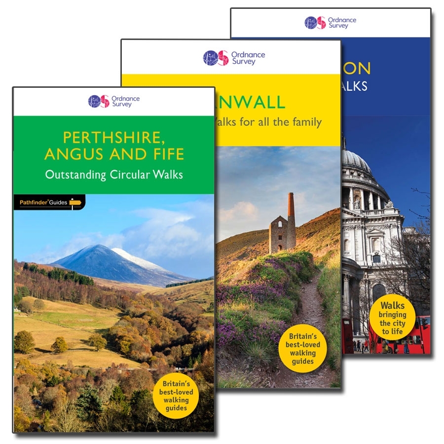
The Pathfinder series has been inspiring walkers across Britain since 1989. Each guide is curated by an experienced writer and features 1:25 000 route maps (the same detail as the orange OS Explorer range). The series features more than 80 titles, and offers a tremendous range of routes for all walkers, providing the motivation and detail your next adventure needs. Plus the books' durable covers and rounded corners make them ideal for outdoor use.
Pathfinder offers three types of walking guidebooks:
Pathfinder Guides
Each title focuses on a popular area of Great Britain and features 28 outstanding circular walks of varying length. Each walk includes a difficulty rating and detailed route information, highlighting where to park, where to stop for refreshment, and all points of interest along the route. Popular with visitors and locals, they are a great way to discover the best an area has to offer.
Short Walks
This range is smaller and more compact than the Pathfinder Guides, and the walks within have been carefully selected with families in mind. Each book features 20 shorter circular walks, often starting and ending in a town or village, highlighting public transport options, refreshment stops, and public toilets.
City Walks
Offering 15 short and entertaining routes around selected cities (currently London, Edinburgh and Oxford), these titles have been compiled by local guides, and focus on the history and architecture of both iconic streets and more unknown gems off the beaten tourist track. Features easy-to-use route street maps to keep you on course.
Help & FAQ
On the right of the screen your basket summary will show a value of £25.99. Enter your code in the 'discount code' box and update the total to reduce the value to zero. New customers will need to sign up for an account, and existing customers should sign in. At the billing stage you will see a message confirming ‘No Payment Information Required’, as there is nothing to pay. Select ‘Continue’ and then ‘Complete Purchase’ to finish the redemption process.
Close the purchase window and scroll up this page to start exploring the walks online. Click on a link on the map or the route list to open in OS Maps. You will need to be signed in to OS Maps to view the walks on 1:25k scale maps.
OS Maps opens on the free Standard map layer. Use the ‘layers’ button, which looks like a stack of paper on the bottom right of your browser window to switch between the different map layers.
Select 'OS Leisure Maps', and then zoom in as required to see 1:25k scale mapping.
Change map layer and zoom in to show the area and map type desired then click the print button in the top toolbar. By default you will print whatever map type and scale is visible on screen at the time, but for leisure maps you can change scale in the Print Panel.
The default print option is ‘Fit map to page’, but you can print to exact scale by selecting the ‘Print to scale’ option on the Print panel. The preview box will show how much of the route fits on the page - you may need to change the paper orientation or print two or more pages for longer routes.
On the Print panel, tick the ‘Show Waypoints’ box and the ‘Include Route Card’ box. This should be the default setting for the walks in this collection.
The ‘Favouriting’ feature in OS Maps allows you to select the walks you want to follow. In your browser, click ‘Add to favourites’ on the left-hand route details screen (you will need to be logged in to do this). This syncs to the OS Maps app app, where your favourite routes will appear as a separate tab under ‘My Routes’. Offline mapping for routes does not download automatically - you need to select the 'download' option underneath the route name.
You can access the OS Maps support page for guides, FAQs and more.