Ordnance Survey Short Walks Made Easy Range
About the Range
The perfect guidebooks for customers with no previous walking experience or specialist gear, featuring bottom-of-the-hill walks in some of Britain's favourite outdoor places.
- Ten easy-to-follow leisurely walks per title
- Routes ranging from 2 to 5 miles
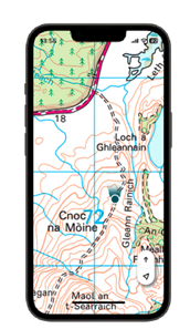
- Four ways to follow a route: simplified mapping, route profiles, turn-by-turn instructions, and walk photography
- Stunning scenery in quieter areas: National Parks, Areas of Outstanding Natural Beauty, Coastal Paths, and more
- Packed with essential information:
- Public transport links and parking spots
- Terrain and footwear information
- Refreshment stops including pubs and cafes
- Public toilet markers
- Nature notes for the area
- Stories behind each walk
- Highlighted accessibility sections for wheelchair and pushchair users
- Dog friendly information
To get started with your 1-month free OS Maps Premium Subscription
- Scratch off the panel in the rear of the guidebook to reveal your unique code
- Visit os.uk/redeem
- Follow the instructions on the page to activate your subscription, which is valid from the time you activate it
Video Guides of OS Maps
For more help & support materials, head to our FAQ pages where you'll find answers to some of the most common questions asked about OS Maps.
Using QR Codes in the guidebook
- Scan each QR code to see the route in OS Maps App. NB You may need to download a scanning app if you have an older phone
- OS Maps will open the route automatically if you have it installed. If not, the route will open in the web version of OS Maps
- Please click Start Route button to begin navigating or Download Route to store the route for offline use.