Custom Made maps FAQ
All the help you need to make the best out of your personalised mapping


Below the location search, you can choose from Explorer 1:25 000, Landranger 1:50 000 and for selected products Explorer Enlarged 1:10 000 map types. Explorer shows a smaller area, but in more detail, while Landranger shows a larger area, but in less detail. Explorer Enlarged is a magnified version of Explorer, great for small areas like a town or suburb.
If you change scale, the centre will be at the same location, but the area covered will change.
You can either enter a place name, grid reference or postcode in the search box, or drag the map to select a location. If you are using a touchscreen, be careful not to move the map accidentally when moving around the screen.
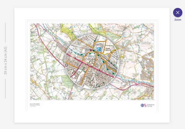
Once you are happy with the area covered verify the map is in exactly the right place, and continue. Use the 'zoom' button to show a zoom tool, which is useful for checking the detail to see exactly what's covered.
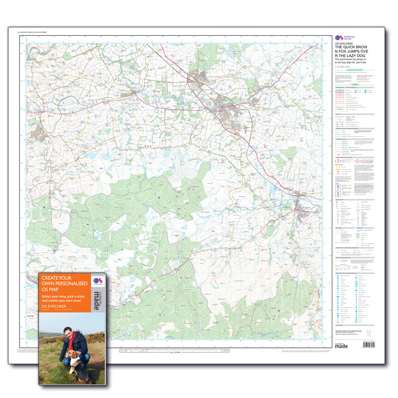
If you are creating a folded map the exact centre will be in a horizontal and vertical fold, so you may want to move the map slightly so that the feature in the centre is not on a fold line. Maps are printed exactly as shown in previews. Large maps are printed complete with a legend on the right side, numbered grid lines and magnetic variation for the area.
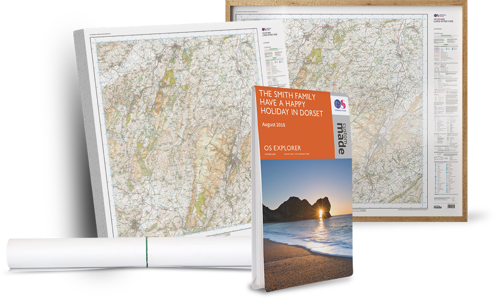
The area covered varies by product and map scale. The table below lists the different products and the ground area covered:
| Product | Map Series | Area | Square Km |
|---|---|---|---|
| Large Folded Map | OS Explorer 1:25000 | 20 x 20km | 400 |
| Large Folded Map | OS Landranger 1:50000 | 40 x 40km | 1600 |
| Large Flat Map | OS Explorer 1:25000 | 20 x 20km | 400 |
| Large Flat Map | OS Landranger 1:50000 | 40 x 40km | 1600 |
| Large Flat Map | OS Explorer Enlarged 1:10000 | 8 x 8km | 64 |
| Large Framed Map | OS Explorer 1:25000 | 20 x 20km | 400 |
| Large Framed Map | OS Landranger 1:50000 | 40 x 40km | 1600 |
| Large Framed Map | OS Explorer Enlarged 1:10000 | 8 x 8km | 64 |
| Large Canvas | OS Explorer 1:25000 | 20 x 20km | 400 |
| Large Canvas | OS Landranger 1:50000 | 40 x 40km | 1600 |
| Large Canvas | OS Explorer Enlarged 1:10000 | 8 x 8km | 64 |
| Large Canvas Framed | OS Explorer 1:25000 | 20 x 20km | 400 |
| Large Canvas Framed | OS Landranger 1:50000 | 40 x 40km | 1600 |
| Large Canvas Framed | OS Explorer Enlarged 1:10000 | 8 x 8km | 64 |
| Small Folded Map | OS Explorer 1:25000 | 10.5 x 7.4km | 77 |
| Small Folded Map | OS Landranger 1:50000 | 21 x 14.5km | 304 |
| Small Framed Map | OS Explorer 1:25000 | 9.75 x 6km | 58.5 |
| Small Framed Map | OS Landranger 1:50000 | 19.5 x 12km | 234 |
| Small Framed Map | OS Explorer Enlarged 1:10000 | 3.9 x 2.4km | 9 |
| Medium Framed Map | OS Explorer 1:25000 | 13 x 8km | 104 |
| Medium Framed Map | OS Landranger 1:50000 | 26 x 16km | 416 |
| Medium Framed Map | OS Explorer Enlarged 1:10000 | 5.2 x 3.2 km | 16.5 |
 In the 'Area and Style' tab where you select a location, a preview of your map will be shown in the main window, so you can see an overview. Click the 'Zoom' button in the top right to see the detail of the centre point.
You can drag the zoom circle to any part of the map, which is useful for checking if a particular location is included.
You will also be shown a preview at the final stage, before adding your created map to your basket.
Once you have selected a map type, you will be asked to enter title text. Your text will appear both in the top right corner of the map, and on the cover if you choose a folded map.
The title layout varies by product type:
- On large products there are five lines of text; the first three ‘title’ lines will always appear in upper case, while the sub-title lines will appear as you enter them.
- On medium and small framed products there are two lines of text; one ‘title’ line in upper case and one sub-title line where text will appear as you enter it.
- On small folded maps there are three lines of text; two ‘title’ lines in upper case and one sub-title line where text will appear as you enter it.
The amount of text you can enter is limited by the total width, not a specific character count, but we will warn you if you try to include too much. If you see a message ‘Please shorten the text’ you may need to delete the last character before you can proceed.
We may impose some limitations on language used on map covers.

Adding your own photo
Upload a photo you have saved. It must be:
- JPEG (extension jpg or jpeg), GIF (.gif) or PNG (.png) file format
- Larger than 200 Kilobytes and less than 10 Megabytes
Images smaller than 0.2 Megabytes (200 kilobytes) are usually too low quality for printing. For larger files, you can reduce your image size using your favourite editor. You can also edit your photo for brightness, contrast and colour on your device before you upload it using a photo editor.
If your photo isn’t suitable for printing you will see an error message. Generally, if you are using a PC/laptop and you right click on the photo and select ‘Properties’ it will confirm the size of your photo.
Portrait images work best, but don’t worry about the exact dimensions – you will get the option to crop the image in the next stage.
Portrait images work best, but don’t worry about the exact dimensions – you will get the option to crop the image in the next stage.
Once you are happy with your image, use the ‘upload’ button to select your image.
See our terms and conditions (Part 11) for some restrictions on images that can be used.
Cropping and placing your image
In the crop tool, drag the highlighted area to select what will appear on the cover. Parts outside the dotted white lines show areas that may be trimmed during printing. At this stage there is also the option to rotate the image if required. Once you’re happy, select ‘Place image’.
Image upload problems
The most common reasons for compatible images failing to upload is that cookies have been disabled. Please change your browser setting to allow cookies, at least for the duration of your purchase.
Stock Images
If you prefer, you can use one of our stock images to illustrate the cover.
Images that are uploaded are kept for a time to allow for customers not ordering immediately, and for reprints. These retention periods are:
- An image uploaded, but the map has not been added to basket: 6 months
- An image uploaded and added to basket, but not purchased yet: 3 months (in addition)
- After order completion: 60 days
After this time the image is deleted automatically. If you want to make another map using the same image, you will need to upload it again. If the map has been in your basket for more than 9 months (in total) you will need to 'remove from basket' and start again. For more information on how we handle personal information (which would include photos with people) see our Privacy Policy.
You now have the option to display a route on your map, either by choosing one of our recommended routes or by uploading your favourite route!
Recommended routes
In the ‘Area and Style’ tab select ‘Display a Route’ and choose a route from the drop-down list. We will show you the best routes for your chosen product size.
Upload a Route File
To add your own route you’ll need to upload a .gpx file – you can get hold of this by exporting from OS Maps (or your chosen mapping website or app). Then select ‘upload your GPX’ and pick your chosen route file.
Once you have chosen a route you will be able to adjust the thickness, transparency and colour of the route line, to customise however you like.
What if my route doesn’t fit?
If your route doesn’t display well, we will show you a warning message to let you know it is too big or too small and suggest whether we think you’d be better to select a different scale or may need to choose a different sized product.
To allow for a larger extract of map some of our products don't include a legend / key. You can find one for Explorer maps, for OS Landranger Maps or in OS Maps web or App.
Due to the print process we are unable to laminate our Custom Made maps, therefore we are unable to offer weatherproof custom maps at this time.
If you intend to laminate your map or have it framed elsewhere, please be aware that Ordnance Survey Custom Made maps are printed using 'Toner Crystal Point' technology. This enables the fine detail to be achieved that is not possible using inkjet on uncoated map paper.
Applying heat or solvents to the printed product again will 're-activate' the toner causing the image to run and spread so we recommend that you:
- Don’t use hot mount framing processes, don't hot dry mount the map
- Don’t encapsulate or laminate the map using a hot heat process
- Don’t use adhesives on the map
Hinge mounting or dry, cold mounting using acid free adhesive and acid free board is recommended.
Yes. Large framed maps are supplied with D-rings and hanging wire. Medium and Small framed maps have a hanger attached. You will need to use your own wall fixings.
Yes. At the last stage of the process you will have the ability to add multiple copies of the same map. There are bulk discounts available if you order 10 or more of either the same or different Custom Made maps.
Flat and folded paper Custom Made maps ordered before 2pm on a working day are printed the same day but posted the next day to allow for the prints to dry and covers to be attached. Orders placed after 2pm or on a non-working day will start printing on the next working day. Standard postage via Royal Mail will take 2-5 working days from despatch (For a total of 4-7 days). If you choose the courier delivery order, it will be delivered with 48 hours of despatch, and will need to be signed for.
Canvas and framed maps take 10-12 working days for manufacture and delivery and are despatched through DHL 24 hour or Parcel Force 48 hour delivery. They are packed securely in well-padded boxes. The boxes are approx. 1200mm x 1000mm x 100mm for large maps, so please ensure you have the space if you plan to collect them from your local delivery office by car!
Delivery make take longer in busy periods, this will be indicated at checkout.
Custom Made maps don't cover a specific area, so unlike ordinary OS Explorer or OS Landranger maps do not come with a Digital Download code. As we are unable to provide this service we offer a free one month subscription to OS Maps Premium with all custom made purchases. A code will be sent to you by email the day after your purchase. OS Map premium users can download any area of mapping using the 'save offline map' option in the app, or you can get a digital download with standard Explorer and Landranger paper maps.
OS Custom Made maps are made to your specification. Therefore they cannot be returned or refunded unless they are delivered damaged or with printing errors. This includes:
- Where you have selected the wrong area or map scale. Please double check the map preview before ordering.
- Where you have made an error in the titles. Titles will be printed exactly as you have entered and are shown in the preview. We don't correct spelling before printing.
- Where the wrong image or a poor quality image is used on the cover. While we always try to print the cover images as clearly as possible, but where the image uploaded is of low quality this will appear the same on the cover. Please check your images before uploading.
If your Custom Made map is damaged or not as ordered, please see the Returns information for help. We will contact you to give you the option to either receive a full refund or a replacement.
Unfortunately, we will be unable to refund you if the map was damaged after it was received, such as if you use a hot lamination process.
You can see our full Terms and Conditions here.

